


This page last modified 2003 August 08
Leying the Duke to Rest
Introduction
In 1846, the Rev. Edward Duke published a book called The Druidical
Temples Of The County Of Wilts. In this book he proposed that various
ancient sites on the Marlborough Downs and Salisbury Plain represent the
construction of a giant "stationary Orrery" built on the land. Duke
asserted that, not only were the distances correct, but that all except one fell
on a straight (ley) line. This notion has been revived and extended by modern
newage "alternative thinkers". Let us properly examine these claims.
The Claims
Duke claimed that the following sites represented different object in a geocentric solar system:
| Site | Object | |
| Silbury Hill | Earth | |
| Avebury north stone circle | Sun | |
| Avebury south stone circle | Moon | |
| Walker's Hill long barrow | Mercury | |
| Winterbourne Bassett stone circle | Venus | |
| Marden henge earthwork | Mars | |
| Casterley Camp earthwork | Jupiter | |
| Stonehenge | Saturn |
One of the many curiosities of Duke's "cosmology" is that the Moon
orbits the Sun!
This has since been "updated" to include other planets, etc.
| Site | Object | |
| Cotmarsh [1] | Asteroid belt | |
| Belas Knap long barrow | Uranus | |
| Christchurch harbour [2] | Neptune | |
| Lickey End [3] | Pluto |
[1] As is typical of "alternative thinkers",
the exact location in Cotmarsh is not given. The purpose of this vagueness is an
attempt to make the claims difficult or impossible to either falsify or verify.
It is a standard pesudoscientific ploy.
[2] The exact
location is again vague, and is sometimes given as various barrows on
Hengistbury Head, which is adjacent to the harbour. Others claim that it is in
the harbour itself, as befits the god of the sea. It's probably better not to
ask how it was known, in antiquity, that 19th Century Europeans would choose the
name "Neptune" for this planet.
[3] The claims
vary from "Birmingham" to "near Lickey End" (no, I promise I
did not make that name up! [grin]) to "the base of Lickey Hill"
(which is over 1 km long!).
Examining the Claims
It is possible to establish the central positions of most of these sites to a precision of 100m using 6-figure Ordnance Survey grid references:
| Site | OS Grid Ref. | |
| Silbury Hill | SU 100686 | |
| Avebury north stone circle | SU 103701 | |
| Avebury south stone circle | SU 104699 | |
| Walker's Hill long barrow | SU 112634 | |
| Winterbourne Bassett stone circle | SU 094755 | |
| Marden henge earthwork | SU 091584 | |
| Casterley Camp earthwork | SU 115535 | |
| Stonehenge | SU 122422 | |
| Belas Knap long barrow | SP 021255 | |
| Christchurch harbour | SZ 175915 |
SP and SZ are the 100km sheets due north and due south respectively of sheet SU.
Now, the useful thing about OS Grid Refs is they make it extremely easy to establish distance and direction. Simply putting the grid references into a CAD program plots the points, and the dimensioning tool will give distances and angles. Ley lines are supposedly straight. Obviously, exactitude is impossible to achieve, so what would a reasonable tolerance be? With the unaided eye, it is trivial to notice a misalignment greater than the thickness of a little finger held at arm's length, so it would not be unreasonable to expect alignments to fall within that, so we shall use that as our allowable tolerance: 0.5º. For distances, let us allow a generous tolerance — say 10%. Plotting the points supposed ley line gives us this:
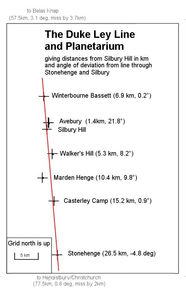
Taking a base line from Stonehenge to Silbury, we can see that the only other point that falls within our tolerance is the circle at Winterbourne Bassett. Marden Henge is acknowledged to be "off", but the others are supposed to be on the line. They aren't! (The red line has a scale width of 30m).
So, the straight line hypothesis is falsified, but what about the distances? Surely they must fall within 10% of some accepted values. From the above data, an Astronomical Unit (1AU), i.e. the mean separation of Earth from the Sun, is represented on the ground orrery by 1.4 km. We can work out from this what the distances on the ground should be and compare them to the distances of the chosen monuments:
| Site (Planet) | Ground Measure (km) |
Scaled Mean Distance from Sun (km) | ||
| Silbury Hill (Earth) | — | 1.4 | ||
| Avebury north (Moon) | 1.5 | 1.4 | ||
| Avebury south (Sun) | 1.4 | — | ||
| Walker's Hill (Mercury) | 5.3 | 0.56 | ||
| Winterbourne Bassett (Venus) | 6.9 | 1.0 | ||
| Marden Henge (Mars) | 10.4 | 2.1 | ||
| Casterley Camp (Jupiter) | 15.2 | 7.3 | ||
| Stonehenge (Saturn) | 26.5 | 13.4 | ||
| Belas Knap (Uranus) | 57.5 | 26.9 | ||
| Christchurch Harbour (Neptune) | 77.5 | 42.1 |
It is blatantly obvious from the above that there is no relationship between the distances in the two columns and I suggest (i.e. this is a challenge to "alternative thinkers"!) that no consistent method exists of deriving one set of figures from the other.
In short, what we have is a complete nonsense. It is just another one of the
many ways in which unscrupulous "mystery mongers" exploit the
ignorance and gullibility of their "marks". Shame on them!
